Laster's Fine Art & Antiques

Winston-Salem, NC

Higher net worth estates and collections professionally, discreetly and effectively sold since 1973


Home


Contact Us


Search


Retail Store


Estate Settlement


We Buy...


Battle Of Gettysburg Cyclorama

_______________________


Antique Maps


Antique Prints


Autographs & Documents


Leather-Bound Book Sets


Original Drawings


Original Paintings


Rare Books


Other Items


Antique Maps Page 4...


CENTRAL USA


"Diagram Of The State Of Missouri" Office of the Surveyor General (M. Lewis Clark) for the States of Illinois and Missouri, Saint Louis October 28th, 1849. Map has several folds and is lightly foxed and toned, primarily in the upper portion. Measures 18 3/4" x 23." - $145


S. Augustus Mitchell: "County Map of Minnesota," 1874. Original Hand-Colored Single-Page Map from Mitchell's New General Atlas. Measures 15 1/4" x 12 1/4." Light foxing. - $125


S. Augustus Mitchell: "County Map of the State of Illinois," 1874. Original Hand-Colored Single-Page Map from Mitchell's New General Atlas. Measures 12 1/4" x 15 1/4." Light foxing. - $80


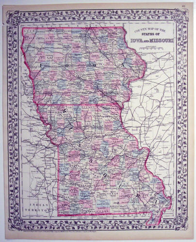
S. Augustus Mitchell: "County Map of the States of Iowa and Missouri," 1872. Original Hand-Colored Single-Page Map from Mitchell's New General Atlas. Measures 15 1/4" x 12 1/4." Light foxing and a small chip in the upper left-hand margin. - $75


See More Maps...

CONTINENTS & COUNTRIES  -  USA  -  WESTERN USA  -  SE USA 1  -  SE USA 2  -  NE USA 1  -  NE USA 2